Find Selective Schools Near Me in NSW (Interactive Map)
"Which selective high schools are near me?" It is usually the first question a NSW parent asks after deciding their child will sit the Selective High Schools Placement Test — and until now the answer involved scrolling a long PDF and flipping to Google Maps to work out which schools you could actually commute to. AcePath's new nearby selective school finder turns that into a single search box and an interactive map of every fully and partially selective high school in NSW.
What Counts as a Selective High School?
NSW runs four kinds of selective entry, all using the same placement test:
- Fully selective high schools — every student in the school has been admitted by test (e.g. James Ruse, North Sydney Boys, North Sydney Girls, Sydney Boys, Sydney Girls, Baulkham Hills, Normanhurst Boys).
- Partially selective high schools — selective stream within an otherwise comprehensive school. Lower entry mark, broader school culture. See our partially selective explainer.
- Agricultural selective schools — residential schools with an agricultural focus (Hurlstone, Yanco, Farrer, Macquarie Fields).
- Aurora College — a virtual selective school for students in rural and regional NSW.
All of them appear on the same map. Year 5 students apply and the placement test sits in Year 6 for Year 7 entry. (If you are looking for primary-school Opportunity Class instead, see find OC schools near me.)
The Nearby Selective School Finder — How It Works
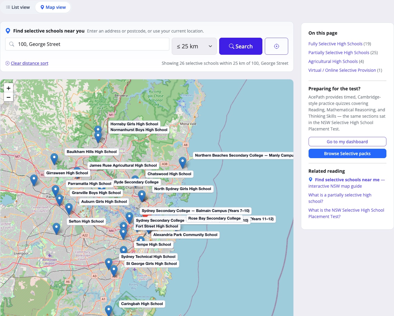
Open /selective-schools — our directory of every NSW selective high school. Click Map View, at the top of the page sits a "Find selective schools near you" search card. Here is what it looks like in action — a search for the postcode 2150 (Parramatta) with the map view open:
From there you can:
- Type an address or postcode — e.g. "100 George St Parramatta" or "2150" — and the directory instantly re-sorts by distance from that point.
- Tap the crosshair "use my current location" button — the browser asks permission, then we list the closest selective high schools to wherever your phone is right now.
- Filter by radius — 10 km, 25 km, 50 km, or any distance — so you only see selective schools within a realistic commute.
- Switch to map view — a full-width Leaflet map locked to the NSW bounds drops a pin on every selective school. Click any pin for a popup with the school name, suburb, type (fully / partially / agricultural), distance from your search point, and a one-click "Get directions" link that opens Google Maps with your address pre-filled as the origin.
Find Selective Schools Near Me in 60 Seconds
- Open /selective-schools.
- In the "Find selective schools near you" card, start typing your home address or postcode. Suggestions appear as you type — pick one to lock it in. (Or hit the crosshair icon to use GPS.)
- Pick a maximum distance. 25 km works well across most of Sydney; widen to 50 km for outer suburbs or "any distance" if you live in regional NSW.
- Hit Search. The list re-sorts by kilometres-from-you, and a "distance" column appears next to every school.
- Click "Map view" to see every selective high school plotted on the NSW map. Click any pin to grab driving directions in one tap.
Why Distance Matters So Much for Selective High School Choice
- Six years is a long commute. Year 7 to Year 12. A 90-minute door-to-door trip compounds into more than a thousand hours of travel over the six years — time that could be spent on sleep, sport, or homework.
- Top-tier marks vs. realistic options. Aiming only at top-five fully selective schools is high-risk if you live an hour away from all of them. The map exposes the partially selective and mid-tier fully selective schools you can actually commute to, which makes for a far stronger four-school preference list.
- Public-transport feasibility decides daily life. Once your child is in high school they will usually travel alone by train or bus. The "Get directions" link, switched to transit mode in Google Maps, tells you whether that trip is realistic for a 12-year-old at 7 a.m.
- School culture is local. A selective school an hour away rarely ends up being a school where your child's friends and weekend life are centred. The closer options often win on quality of life even when the league-table ranking is a notch lower.
How Preference Strategy Uses the Map
The NSW selective application lets you nominate up to four schools, in order of preference. The map view of /selective-schools helps you build a balanced four-school list:
- Preference 1 — stretch. The highest-ranked fully selective school you would seriously attend, within reach by commute.
- Preference 2 — match. A fully or partially selective school with a realistic entry mark for your child's practice scores.
- Preference 3 — safety. A partially selective school nearby — often the smartest preference of all. See our partially selective explainer for why.
- Preference 4 — wildcard. Aurora College (virtual) or an agricultural selective if either suits your circumstances.
Listing four schools you cannot realistically commute to wastes the application. The distance-sorted list and the map view together stop you from doing that.
What the Map View Shows You That a List Cannot
- Density. The North Shore, Inner West, and Hills District are dense with selective options; the Northern Beaches has almost none. Map view shows you which side of that line your family sits on at a glance.
- Direction. Many families discover their nearest selective is in a direction they never travel. Better to know before you waste an open day.
- Train-line alignment. Selective school commutes live or die on the train network. Cross-referencing a school's pin with the Sydney Trains map saves a lot of guessing about whether a 7 a.m. trip is plausible.
Privacy: Where Does Your Location Go?
The selective finder runs entirely in your browser. When you tap "use my current location" your latitude and longitude are used to sort the list and centre the map — they are not sent to AcePath's servers and they are not stored. Typed addresses are looked up via a public Australian geocoder and likewise never recorded against your account. No login required.
Frequently Asked Questions
Which selective high schools are included?
Every fully selective, partially selective, agricultural selective, and virtual selective (Aurora College) school listed in the current NSW Department of Education directory. If the Department adds or removes a selective stream, our directory is updated for the same application cycle.
Does the finder include partially selective schools?
Yes — fully and partially selective schools are shown on the same map, with a label on each marker. Many families overlook partially selective schools and miss the strongest realistic preference on their list. See our partially selective explainer for why these schools deserve a spot.
Does the finder work outside NSW?
The directory lists NSW selective high schools only — the Selective High Schools Placement Test is a NSW program. You can still search using any Australian address as your starting point (handy for interstate families relocating to Sydney), but the map is locked to the NSW bounding box.
Is the selective nearby finder free to use?
Yes — the selective schools directory, the address search, the map view, and the Google Maps directions links are all completely free. No account required.
What is the closest selective high school to my postcode?
Type your postcode into the search bar at the top of /selective-schools and the list re-sorts instantly — the school at the top of the table is your closest selective option, with distance shown in kilometres.
How are distances calculated?
Great-circle (straight-line) distance between your search point and each school's plotted location. For the actual driving or public-transport time, click "Get directions" on the map popup or any row — Google Maps opens with your origin and destination pre-filled.
What if my closest school has a very high entry mark?
Look at the next two or three schools on the distance-sorted list. Pairing a "stretch" fully selective school with a realistic mid-tier school and a safer partially selective option — all within commuting distance — is almost always a stronger four-school preference list than four long-shot top-tier picks.
Try It Now
Open /selective-schools, type your postcode, and see your closest selective high schools on the map in under a minute.
Once you have your shortlist, see where your child currently sits with a free AcePath selective sample quiz, or jump into a full selective practice pack built to match the NSW Selective High Schools Placement Test format.
Start Practising Today
Try a free sample quiz to experience AcePath's exam-style practice tests.
Try Sample Quiz Register Free